Water Cay Dune Reserve Estate
Roughly 381 freehold acres with over 7,000 feet of beachfront — and a plan that refuses to build on any of it. The architecture withdraws behind the dunes; the beach stays in charge.
WATER CAY · TURKS & CAICOS
Over 7,000 feet of beachfront, and the most valuable design decision is to leave it alone.
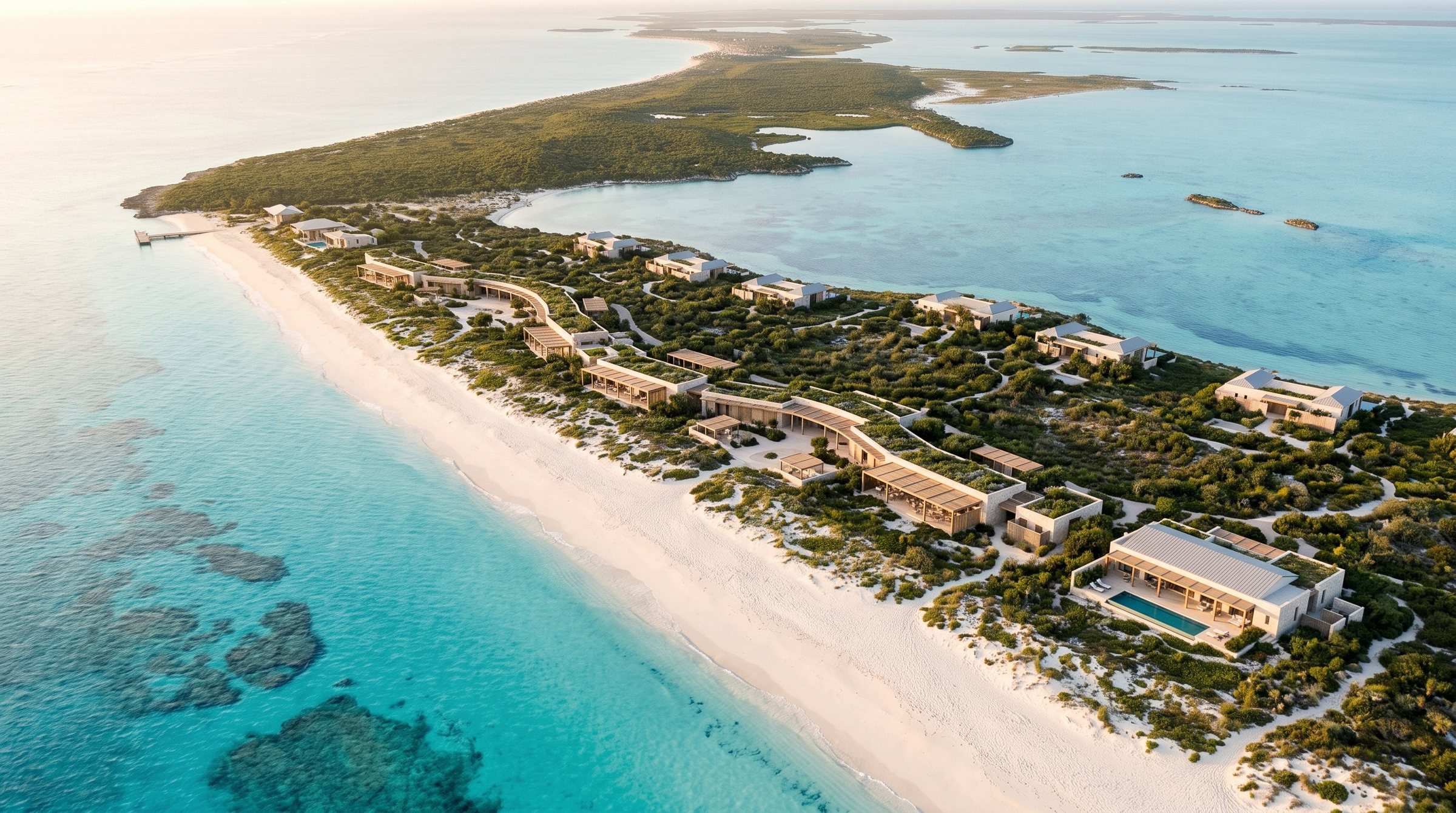
Water Cay lies a short boat ride from Providenciales: roughly 381 acres of freehold land, undeveloped, with rolling ridgelines and more than 7,000 feet of beach. Its zoning is flexible; its ecology is not. Government planning material flags sensitive public and environmental considerations, and neighbouring Little Water Cay is protected habitat for the Turks and Caicos rock iguana. The obvious commercial move — a wall of beachfront villas — would spend the island's capital in one generation. This design takes the opposite position. The dunes and beach become a reserve; the architecture forms a low, shaded line behind the vegetation; villas climb to the ridges. What guests buy is the horizon, kept intact.
| Location | Near Providenciales, Turks & Caicos Islands |
|---|---|
| Site | Approx. 381 acres, freehold, undeveloped; over 7,000 ft of beachfront and rolling ridgelines |
| Programme | 50–80 keys, villas and residences in the early masterplan; beach club, wellness and conservation trails; strongly phased |
| Identity | Conservation-led beach estate with architecture behind the dune line |
| Status | Publicly listed as available with flexible tourism zoning; adjacent Little Water Cay is protected iguana habitat. No affiliation. |
| Stage | Resort design — architecture, structure, MEP, BIM |
Behind the dune line.
§03 — Masterplan strategyEvery major element of the plan is positioned by one rule: the beach and dunes come first.
The masterplan reads the island as a section, from water to ridge: open beach, protected dune reserve, a shaded spine of public functions, then villas on the higher ground. Conservation corridors run through the plan rather than around it, and Little Water Cay sits entirely outside the development logic. Arrival is by tender, with minimal dock impact; services hide inland behind vegetation.
Beach reserve
The full beachfront remains open, protected and visually dominant, with no continuous line of villas on the sand. Main buildings hold conceptual setbacks of 30–50 metres from sensitive beach and dune areas.
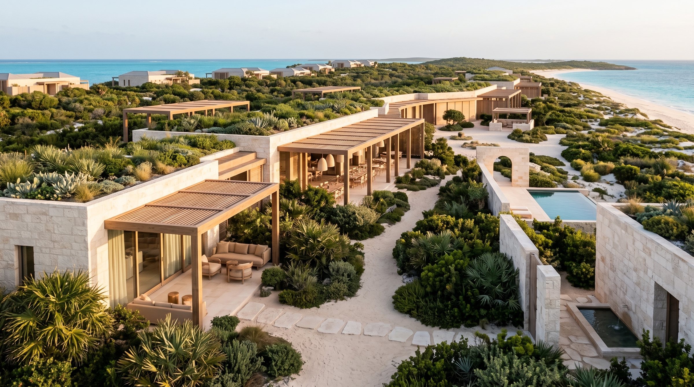
The Dune Line spine
Reception, beach club, restaurant, spa threshold and lounges gather into one low element behind the dune vegetation, linked by landscape courtyards, with guest circulation and service routes kept firmly apart.
Ridge villas
Villas take the ridgelines and slightly elevated ground — better views, better breezes, and floor levels lifted clear of storm surge. One to two storeys, low-rise by rule, screened from the beach by vegetation.
Conservation corridors
Protected corridors connect dune, inland habitat and sensitive ecological zones across the island. Biosecurity is part of the brief: no cats, no dogs, invasive-species control and managed waste, protecting the rock iguana population nearby.
Arrival and services
Access is by boat and tender with limited dock impact; there is no marina in the plan. Back-of-house, energy and water infrastructure sit inland, screened by vegetation and sized for phased growth.
The Dune Line.
§04 — The iconic pieceA low, almost invisible line of shade behind the beach — the resort's public life without its mass.
The Dune Line gathers arrival, reception, beach club, restaurant, spa threshold and shaded lounges into a single horizontal element tucked behind the dune vegetation. Light timber structures and pale limestone walls carry pergolas and planted roofs; sand-coloured materials and wind screens let it recede into its own landscape. Courtyards break the line into rooms, guest circulation runs behind it, and low lighting keeps the beach dark at night.
It is deliberately simple to build: single-storey pavilion construction on foundations set by geotechnical study, hurricane-rated roof systems, corrosion-resistant connections and impact glazing. Because the building is low and porous, wind load and storm exposure fall, and the dune itself remains the first line of coastal defence.
Architecture, engineering, ecology.
§05 — The technical layersHidden luxury, pale palette
Turks and Caicos coastal minimalism: low horizontal pavilions in pale limestone, timber and sand-coloured plaster, with bronze-toned metal, woven screens and solar pergolas. The architecture is designed to be barely seen from the water; native dune vegetation is treated as a facade material in its own right.
Built for the storm season
Structures are elevated where storm surge risk exists, on pile or shallow foundations determined by geotechnical study. Hurricane-rated roofs, engineered tie-downs, corrosion-resistant connections and impact glazing or shutters throughout, with the emergency shelter and evacuation protocol carried as core design scope.
Dark skies, closed loops
A microgrid with solar and battery storage, desalination and water storage, and tertiary wastewater treatment with no nutrient discharge near marine habitat. Stormwater infiltrates where it falls. Lighting is dark-sky and wildlife-sensitive across the island, keeping beaches viable for nesting and the night sky legible.
Evidence before geometry
The design assumes full EIA, ecological survey, beach and dune study and coastal engineering review before any design is fixed. The BIM model is structured to absorb that evidence — setbacks, flood levels and habitat boundaries held as data, so every future revision is checked against the constraints.
The luxury is the horizon. The architecture's job is to stay out of it.
It sharpens a discipline the studio applies everywhere: letting site evidence — dunes, surge, habitat — set the geometry before architecture claims any ground. Water Cay is privately listed freehold land; we have no affiliation with its owners, brokers or the Turks & Caicos authorities. The design treats the island as highly environmentally sensitive: any real project would require full EIA, ecological survey and coastal engineering review, with Little Water Cay's protected habitat untouched.
If a project here became live, we would work as the technical partner alongside the licensed local consultants who carry statutory responsibility in the jurisdiction — the architect of record, structural checkers, MEP and utilities engineers, and the environmental, coastal and fire specialists the approvals require. Our role is design, structural engineering, MEP coordination, BIM and construction-oriented documentation.